Last Updated: April 17, 2024


Start

Recent content updates are viewable under what's new.

Reports in the queue for posting are coming soon!

Upcoming reports & photos:

Oh my! Quite the backlog here, eh?

  • American Mountain & Mount Lincoln - hike/snowshoe (May 2023)
  • Mount Mclean Attempt, Red Rock Trail, Dragons Back Trail - hike (May 2023)
  • Stawamus Chief (South, Middle & North) - hike/scramble (June 2023)
  • Flint & Feather - hike/scramble (June 2023)
  • Goat Ridge (Squamish) - hike (June 2023)
  • Grouty/Mortar Peaks - hike/scramble (June 2023)
  • Pebble-to-North Creek Traverse incl. Pebble, Thiassi, Wesley & Sugus - hike/scramble (July 2023)
  • Mount Truax - hike/scramble (July 2023)
  • Blackcomb Buttress - rock climb (July 2023)
  • Whitecap Peak - hike/scramble (July 2023)
  • Mount Hanover - hike/scramble (August 2023)
  • The "Long Traverse" incl. Long, Tynemouth, Arrowhead, Tabletop & Anemone - hike/scramble (August 2023)
  • Armchair Traverse - hike/scramble (August 2023)
  • Snowspider Mountain - hike/scramble (September 2023)
  • Mount Trorey - hike/scramble (September 2023)
  • Macleod Peak - hike/scramble (September 2023)
  • Ben Lomond - hike/scramble (September 2023)
  • Mount Killam & Gambier Island - hike (September 2023)
  • Lone Goat & Snow Camp Mountain - hike (September 2023)
  • Isollilock Peak - hike/scramble (October 2023)
  • Manson - Hatfield Traverse - hike/scramble (October 2023)
  • Gargoyles & Columnar Peak - hike/scramble (October 2023)
  • Opal Cone and Lava Glacier - hike (October 2023)
  • Park Butte (WA) - hike (October 2023)
  • Trappers Peak (WA) - hike/scramble (October 2023)
  • Rattlesnake Ledge (WA) - hike (November 2023)
  • Sauk Mountain (WA) - hike (November 2023)
  • Mount Daniel & Pender Hill (Sunshine Coast) - hike (November 2023)
  • Mount Dickerman (WA) - hike (November 2022)
  • Winter's End (Verona Peak) - hike/snowshoe (November 2023)
  • Dolomites (Italy) - snowboarding (December 2023)
  • Red Rock Canyon (NV) - hike (January 2024)
  • Flute & Oboe - split tour (February 2024)
  • Whistler misc. (Train Wreck, Loggers Lake, Shadow Lake etc.) - hike (February 2024)
  • Mount Underhill - hike (March 2024)
  • Bombtram Mountain - hike/snowshoe (March 2024)
  • Steep Peak - split tour (March 2024)
  • Ruby Mountain (WA) - hike/snowshoe (April 2024)
  • Blustry Mountain - hike (April 2024)

*As of 04/17/2024


Database

Query the reports database, selecting from criteria which include name, location, type, season etc.

Quick Links

Essential links & whatnot:


Jump To

Select from list below to jump to a specific area on this site.


| Latest Posts |


Monday, June 23, 2014

Unicorn Peak - Std (via Snow Lakes), June 2014


Of the peaks that comprise the Tatoosh Range on the south-side of Mount Rainier, Unicorn is the tallest and probably the most interesting of the bunch. Thanks to the Stevens Canyon Road, the peak also benefits from great spring and summer access, making for a very casual 6-mile day trip (car-to-car). The views of Mount Rainier from various points along the way, not to mention the summit itself are outstanding and is the obvious attraction for climbing Unicorn. Making the most of my soon-to-expire National Park entrance permit, the great weather and the fact that the approach was still mostly all snow, there was no time like the present to mount this horned equine!


Friday, June 20, 2014

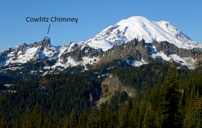
Cowlitz Chimney (Main) - South Route, June 2014


(re-posted from Eric J's nwhikers report) Cowlitz Chimneys is a series of prominent crags visible from many areas on the northeast side of Rainier. The Chimneys are three distinct major pinnacles: North, Middle, and Main Cowlitz. Main (South) Cowlitz is the highest and largest of the three and would be our objective. Sergio had been Jonesing for this peak for a while now, since he sees it every time he's boarding at Crystal. And though I've been to Summerland several times, I've never been past Panhandle Gap, so this was new terrain for both of us. We decided to make this a one-and-a-half day trip to break up the 16 miles and to get some conditioning in for bigger trips this summer.

After a calm night in Summerland, we got going the next morning at 7:15 under bright and sunny skies. At Panhandle Gap we turned right directly up to the little rise, then over it to the other side. We went around this to the left coming back, but it's not really worth the bother unless it's melted out. The route continues up Banshee's gentle W slopes to the summit's fine viewpoint at 7400'. From here Beckey's description of the route is apparent. The "spiry solitary fir" is obvious, so we marched on over to it. Beckey says to then ascend 100'; actually the "horizontal fence of small evergreens" is directly above the solitary fir, so ascend about 50' and start traversing left just above the line of trees. The slope here is quite steep so we faced in and kicked steps sideways. **Note that if you know the approximate location of the cave and slot, at this time of year it's much better to just boot up the snow to directly below and scramble about 75' up to them on class 3 rock, dispensing with the solitary fir and fence of trees traverse.

Due to various delays Sergio and I got separated and so each climbed the rest of the way solo. Once past the trees there is a tiny alcove directly above. Note this but otherwise ignore it. Continue traversing on rock another 100'--I traversed just above the ledge, class 4, solid--till the route comes around a shallow corner to Beckey's "small hidden cave". This isn't a cave at all, merely a larger alcove. Just to the left of the alcove is the short rock slot. This was wet and mossy, and getting up it involved the most awkward moves on the route. Above the slot the route continues directly up for a hundred feet or so on mediocre rock. No need to worry yet; the rock gets much worse. Not necessary to go to the top of the ridge; the route starts traversing up and left not far above the slot as the large summit area becomes visible. Sergio had warned me off going too far left up a harder gully, so I went right. There are plenty of variations across the face to keep you occupied ranging from loose 3rd to low 5th with some exposure, and only those adept at routefinding will succeed in locating the easiest option. Once past the difficulties, easier scrambling led to the false summit, and another 200' horizontal to the true summit of Cowlitz Chimney, 7605'.

As Sergio was waiting below, I stopped only briefly before heading down. To return the route goes mostly up the way on Banshee to avoid steeper sidehilling below. The snow had now turned quite soft, though short of postholing with our snowshoes on. All-in-all, this is worthwhile outing in an interesting area. Most of the peaks on this side of Rainier have a gentle route, so it was more challenging to head up one that involves a bit of routefinding with short but exciting climbing.


Sunday, June 15, 2014

Assorted Flavors, May/June 2014

A slow transition to the usual confection of shoulder season activities thanks to nagging injuries left over from the winter, work and whatnot. Unfavorable Memorial weekend weather put a much anticipated North Cascade ski traverse on the backburner, and with it went any desire for other tours this spring. But all is not lost as we look forward to longer, warmer days and the exploits that await...


home | email | copyright

All photos and text for sverdina.com are copyright © 2002-2024

It would be very much appreciated if you please ask before copying and/or re-publishing content from any part of these pages. To do so, please click here to send a message via feedback form.

Thank You.

©2024 sverdina.com |