Last Updated: April 17, 2024


Start

Recent content updates are viewable under what's new.

Reports in the queue for posting are coming soon!

Upcoming reports & photos:

Oh my! Quite the backlog here...

  • American Mountain & Mount Lincoln - hike/snowshoe (May 2023)
  • Mount Mclean Attempt, Red Rock Trail, Dragons Back Trail - hike (May 2023)
  • Stawamus Chief (South, Middle & North) - hike/scramble (June 2023)
  • Flint & Feather - hike/scramble (June 2023)
  • Goat Ridge (Squamish) - hike (June 2023)
  • Grouty/Mortar Peaks - hike/scramble (June 2023)
  • Pebble-to-North Creek Traverse incl. Pebble, Thiassi, Wesley & Sugus - hike/scramble (July 2023)
  • Mount Truax - hike/scramble (July 2023)
  • Blackcomb Buttress - rock climb (July 2023)
  • Whitecap Peak - hike/scramble (July 2023)
  • Mount Hanover - hike/scramble (August 2023)
  • The "Long Traverse" incl. Long, Tynemouth, Arrowhead, Tabletop & Anemone - hike/scramble (August 2023)
  • Armchair Traverse - hike/scramble (August 2023)
  • Snowspider Mountain - hike/scramble (September 2023)
  • Mount Trorey - hike/scramble (September 2023)
  • Macleod Peak - hike/scramble (September 2023)
  • Ben Lomond - hike/scramble (September 2023)
  • Mount Killam & Gambier Island - hike (September 2023)
  • Lone Goat & Snow Camp Mountain - hike (September 2023)
  • Isollilock Peak - hike/scramble (October 2023)
  • Manson - Hatfield Traverse - hike/scramble (October 2023)
  • Gargoyles & Columnar Peak - hike/scramble (October 2023)
  • Opal Cone and Lava Glacier - hike (October 2023)
  • Park Butte (WA) - hike (October 2023)
  • Trappers Peak (WA) - hike/scramble (October 2023)
  • Rattlesnake Ledge (WA) - hike (November 2023)
  • Sauk Mountain (WA) - hike (November 2023)
  • Mount Daniel & Pender Hill (Sunshine Coast) - hike (November 2023)
  • Mount Dickerman (WA) - hike (November 2022)
  • Winter's End (Verona Peak) - hike/snowshoe (November 2023)
  • Dolomites (Italy) - snowboarding (December 2023)
  • Red Rock Canyon (NV) - hike (January 2024)
  • Flute & Oboe - split tour (February 2024)
  • Whistler misc. (Train Wreck, Loggers Lake, Shadow Lake etc.) - hike (February 2024)
  • Mount Underhill - hike (March 2024)
  • Bombtram Mountain - hike/snowshoe (March 2024)
  • Steep Peak - split tour (March 2024)
  • Ruby Mountain (WA) - hike/snowshoe (April 2024)
  • Blustry Mountain - hike (April 2024)
  • Sowerby Peak (Barr East) - hike (April 2024)

*As of 04/21/2024


Database

Query the reports database, selecting from criteria which include name, location, type, season etc.

Quick Links

Essential links & whatnot:


Jump To

Select from list below to jump to a specific area on this site.


| Latest Posts |


Tuesday, May 17, 2022

Mount Brew (Lillooet) - Northeast Ridge, July 2021


Following in the footsteps of the "Great Ones" of the SWBC Peakbaggers FB group I've been following lately, I made my way over towards Lillooet for a climb of Brew's NE Ridge. At just under 9500 feet, Brew is considered the 5th highest in SWBC and as such commands an impressive panorama overlooking the confluence of lower Cayoosh Creek, Seton River and the mighty Fraser River. It lies in a rain shadow of the endless valleys and peaks to the west and is predominantly comprised of fractured shale, reminiscent of what one might find in the Rockies.

Considering the long drive from North Vancouver, I car camped the night before next to what appears to be an old quarry over in Cayoosh Canyon, a few clicks from Lillooet. Drove Enterprise Creek FSR some 11 km to the parking area the next morning, fully expecting to be devoured by mosquitos the moment I stepped out of the truck. Lo and behold, NO MOZZIES! Left the head net behind and made my way up (down) the trail. As others have noted, a good amount of chainsaw woodworking went into the making of this trail. Trail is generally well flagged but does become indistinct when crossing through waist-high veggie patches higher up. Keep your eyes peeled for flagging and all will be good. Marked trail ends in a small meadow carpeted in mountain lupine below a headwall. Turned up and left and contoured along the base to eventually gain the broad ridge above the saddle at head of Enterprise Creek Valley.

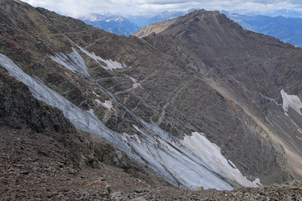
Now in the alpine, I proceeded up and over various sub summits before finding myself at a notch contemplating the steep rock climb back up the other side. It does indeed look worse than it is but take care here as the first couple footholds crumbled beneath my feet as I started up. Cruiser up from there along the ridge, which becomes progressively narrower and more exposed the higher you go. Bailed on the rotten ridge near its end and cut left across the obvious ledge that spans the upper East Face. Much looseness albeit without too much exposure ensued. Turned up after crossing the ledge and endured an exhausting crawl up the scree treadmill for the final pitch to the summit plateau. 4.5 hours to summit. Bit cool and breezy up top with rain evident further off to the SW. Smoke from Lillooet and Lytton fires visible but remained confined to their immediate areas and/or were being blown eastwards. Returned the way I came and back at the truck for a 9.5-hour day including breaks. All in all, a worthwhile outing with unique scenery and fun scrambling, albeit quite loose at times. Oh, and did I mention NO MOZZIES?

Click here to view.

Friday, May 6, 2022

Hope & Wells - via Hope Mtn FSR, July 2021


Picked off the low hanging fruit out by Hope on my return from Coquihalla area. Hope Mountain FSR in great shape, a bit loose with softball-sized rocks in places, but otherwise doable in an SUV (as of last Summer at least). Water bars only on the final ~1km stretch. Easy trail up to Hope summit, 2hrs. Outstanding views! Much less smoke than the day before. Couple benches to take a seat and enjoy the views from up there as well as a toilet where one can do the same should nature come calling. Back down after about an hour wandering about and snapping photos. Didn't use the facilities. Wells next, quick but steep up to the meadows. Meadow area is festooned with new flagging, a bit overkill IMO. Traverse up and left to gain shoulder then short steep grunt to summit ridge, a bit over an hour from parking area. Great views from here too with evidence of fires burning somewhere north of Hope, SE towards Manning and a new one to the ESE that mushroomed dramatically while I was up top. Encountered a large buck with rack on my return from the summit, adding to what is an enjoyably casual outing with much to see both near and far!

Click here to view.
home | email | copyright

All photos and text for sverdina.com are copyright © 2002-2024

It would be very much appreciated if you please ask before copying and/or re-publishing content from any part of these pages. To do so, please click here to send a message via feedback form.

Thank You.

©2024 sverdina.com |