Select from list below to jump to a specific area on this site.
| Latest Posts |
Friday, June 30, 2023
Harris Ridge and Nea Peak - via Taylor Creek FSR, July 2022
Dickson excepted this was an entirely new area for me; that, and I was in search of a venue with somewhat less snow than points further west. Drove up the night before and car camped at the Mowson Pond Recreation Site, which is well maintained and free of charge courtesy of BC Hydro. A passing thunderstorm added some excitement late that afternoon and made for a nice sunset. Pretty sweet spot for a basecamp I gotta say!
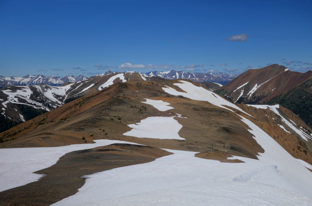
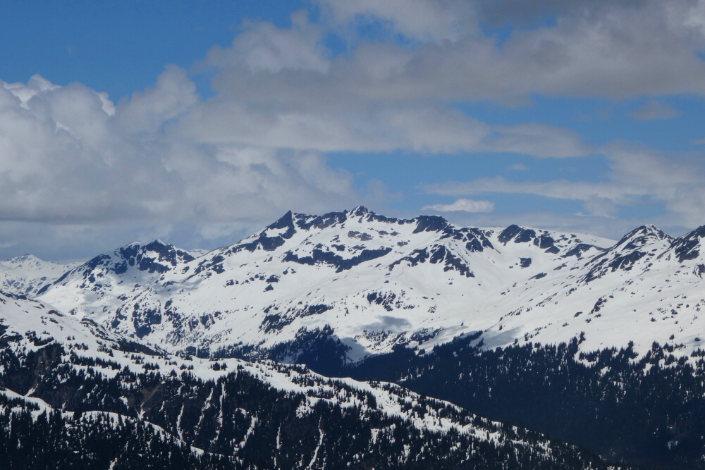
Continued up Tyaughton Lake Road the following morning parking at the second to last fork mentioned in SSWBC as far as I can tell. Bit overgrown in spots, so not very paint friendly. Brought a mountain bike to help dispatch the many kilometers of FSR, especially beyond the washed-out bridge. Made blind guesses at a couple junctions, hoping I would eventually find my way up Taylor Creek Valley. After a good hour of pedaling up a perfectly drivable road, I came upon a creek crossing where a bridge once was, confirming that I was on course. So far so good, the only exception being that I now had to ford this creek in a strong current of thigh-high water. Short but challenging ford barefoot and with bike in arm, didn't look forward to repeating on return. But that was a problem for later, so off I went! Continued up with some bits of hike-a-bike to about 10-15 min shy of the cabin up there as snow patches were becoming more frequent. Mix of travel on snow and scree/dirt gaining the ridge well above the pass and right below Harris false summit. Short but steep snow pitch right at end necessitated axe and crampons but as I discovered later can be avoided by taking to the basin at lookers right, likely left as well. Totally different geology and scenery out here in the South Chilcotins and well worth the visit! Dickson, Sloan, Truax and Shulaps were all hard to ignore from up there. Only one of them left as of this writing, so I guess I gotta go finish that one off next time I'm in the area!
Still had time after bagging Harris, so descended to the pass proper and continued up other side to tag higher Nea. Better views than from Harris and a great add-on without making for a particularly strenuous day! Then back down to where I stashed the bike for a ripper and very wet return to truck. 7ish hours RT. Bypass the one steeper bit and get by with just poles. Fine day out with grand views!
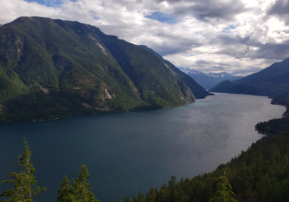
With a forecast for rain covering a good ~3 hour driving radius from home, we set out in hope of finding mountain sunshine on Mission Ridge located near the community of Shalalth, BC. Situated on the north shore of Seton Lake and running about 19km east-to-west from Terzaghi Dam to the town of Lillooet, this area of the Coast Mountains lies in a rain shadow of mountains to the west. Access to the range is generally from either end, where forest roads and trails lead up into the alpine. The western access in particular benefits from a steep but well-traveled road branching off from Mission Pass to reach a clearing at about 6400 ft where there's a fenced off area with communications equipment located within. Backtracking from the clearing a short distance, we continued up the road for a bit higher stopping finally where we were blocked by a snowdrift, about a kilometer or so from the "trailhead". With Mission Peak, roughly half-way along the ridge as our objective, we parked here and continued on foot. The peak, referred to by the First Nations as "The Teat" is the second tallest on Mission Ridge, with Mount Mclean near Lillooet claiming highest status.
Encountered patchy snow on the hike up to the first peak, unofficially named Geodetic Peak and from where there are already outstanding views overlooking Seton and Anderson Lakes! Continued walking for a while longer before reaching a point where one must traverse below the crest on its north side to reach a shoulder with a large basin beyond. I knew from previous reports that following the ridge directly leads to a chasm with technical climbing to get through it. As such, the only alternative was to descend ~1000 feet into this basin only to climb back up it at the other end, and then obviously do the same upon return. Ugh! Agata took one look at this and decided it wasn't for her, plus her back had been giving her grief to this point and she was more than happy to have me now continue on my own. The peak directly above this basin is unofficially named Puck Peak and if push came to shove that'd be as far as I would go, sparing Agata the extra hours of waiting around for me. Snow here was steep and variable, so axe and 'pons came in handy. Gear transitions, snow balling up etc. sapped time and energy. Cold and windy up on Puck, but no rain at least! As for views, I gotta say probably the best bang for the buck is Geodetic, as it has the best perspective on both Seton Lake and Anderson Lake. Higher Puck is comparable, and according to photos I've seen better than from Mission Peak as well. Looked like a lot of annoying ups n' downs along the ridge to Mission from here, so I decided Puck would be it for today. Aside from the lakes, other notable landmarks seen from Puck include peaks such as Brew, Seton and Whitecap. Mount McLean unfortunately isn't visible from here as it's blocked by Mission Peak. May have to come back for that one someday, First Nation's access complications be damned!
Returned via Highline Road rather than driving back through Lillooet for something different (click
here for photos).
highlinehighlinehighlinehighline
Cool to experience at least once! Oh, and do beware the aggressive wild turkey there near the trailhead. Twenty minutes of trying to shoo it away but it just kept approaching. Eventually threw a sheet over it and pinned it down with rocks to subdue the beast long enough for us to get changed up on the truck bed. A first for us!
Mount Sproatt - East Route (via Stonebridge), July 2022
On the west side of the Whistler Valley, directly above the Alta Lake and the village is Mount Sproatt. It is an understandably popular objective for Whistlerite hikers and mountain bikers, with multiple trails leading up to the summit area from the east, south, west and in winter from the north. The lower east summit has a viewing platform and benches with outstanding views of the valley, Whistler and Blackcomb Mountains, and peaks beyond. The true summit, complete with summit dildo (AKA radio repeater) lies only a half kilometer to the NNE and about 200 ft higher. It makes for a quick add-on while significant others prefer to nap on the bench at the viewing platform!
Following the shortest of the various approaches starting from the top of Stonebridge Place on the east side of the peak, we soon picked up Darwin's MTB trail for a bit before taking a right on to the Rainbow-Sproat Flank Trail a few minutes later. We left the biking trail soon thereafter, turning right once more and following a somewhat indistinct path paralleling Millar Creek. The way up became much more defined after the creek crossing, leading up through pleasant old growth forest into the alpine below Sproatt. We eventually lost the trail in snow, but common sense prevailed, and we soon found ourselves out of the trees in the upper creek drainage contemplating where to go next. With the abundant snow coverage still, we elected to turn up and left into a gully of sorts rather than follow the standard route into the basin between the two Sproatt summits. Some steepish snow followed by a fun scramble up a series of ledges saw us to the summit plateau with the viewing platform off to our left. Went there and hung out enjoying the views for a while before continuing solo to tag the summit proper. Respectable scenery for an otherwise lowly peak - the resort peaks, Spearhead Range, Tantalus Range, Callaghan Valley peaks just to name a few. Rendezvoused with my hiking mates on return from true Sproatt and enjoyed some long glissades and boot skiing down to tree line, then followed our tracks back to the dry trail reaching the car not long thereafter. Bit of a hidden gem and nice to still have low hanging fruit such as this to enjoy!
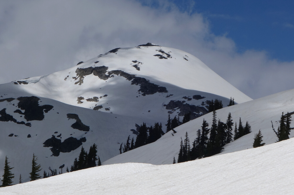
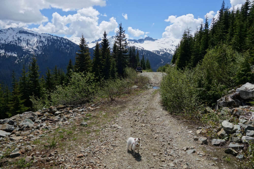
Roughly 13-and-a-half kilometers west of Whistler Village and just to the southwest of the Whistler Olympic Park lies Metal Dome. Technically speaking, the peak is just a subsummit of Brandywine Mountain, a mere 2.6 km away, but is nonetheless a popular objective particularly in the winter or when a low snowline complicates access to the bigger peaks in the area. This is a great ski touring objective in late fall and early winter before the place becomes overrun by sledders. Timed right, spring is also prime season to bag Metal Dome, which it was in early July 2022 courtesy of the extended wet and cold we endured through June. While I didn't risk driving the increasingly rough FSR to its very end, I got close enough to park within a ~15-minute walk of snowline, just a short distance beyond the road's end. Perfect for an easy half-day hike with the pup!
Once on snow, I followed a wide track presumably put in by the snowmobilers over the course of the winter up into the alpine below the peak's SE slopes. Continued up from there following the path of least resistance to reach a small cirque-like feature just below the summit proper. Traversed through this, then hooked back left for a final steep pitch to the top, "short-roping" Pepper through the short exposed-ish bit at the end. Great views from up there, despite some cloudiness obscuring the more distant peaks. Impressive view nonetheless of Mount Fee to the SW, knowing that I'll never set foot on that rotten choss heap. Also, good views of Callaghan Lake with peaks of the Pemberton Icefield beyond, not to mention Tricouni, Callaghan, Rainbow, Sproatt, Castle Towers and Black Tusk. At any rate, not the most glamorous objective, but for a "shorty" this ranks high on the views-to-effort ratio!
Needed to get the heck out of dodge for a couple days to see something new and clear my mind. I'd seen a report on Askom Mountain a while back - a relatively high peak flanking the west wall of the Fraser Canyon near Lillooet, BC and served by a good trail. To make the most of the long drive, I decided to motor over the day before and do a "warm-up" hike nearby on Camelshoof Peak before continuing to the Askom trailhead for the night. Camelshoof is the southernmost summit of the Camelsfoot Range just north of town. While it's not the tallest, it is easily the most popular one. There are excellent 360-degree panoramic views from the peak overlooking a large meander of the Fraser River, the Fountain Range and Mission Ridge, with a good trail leading up the SE Ridge to the lookout up on top (photos:
here).
camelshoofcamelshoofcamelshoofcamelshoofcamelshoofcamelshoofcamelshoofcamelshoofcamelshoofcamelshoofcamelshoofcamelshoofcamelshoofcamelshoofcamelshoofcamelshoofcamelshoof
As with any objective out this way, the crux is always the long drive, so splitting it up over two days is nice. Returning to Lillooet after Camelshoof, one continues onto Texas Creek Road and follows that for what feels like an eternity to the Texas Della Nesikep FSR junction. Drove up this for a while longer, making it to the clearing/campsite without incident and conveniently ignoring the First Nations "No Entry" due to Covid signs. Now that the WHO has declared the pandemic officially over, will they ever take down these silly signs? Anyway, for a car camping spot, this is a primo location with great views overlooking the Fraser Canyon. A popular MTB trail named Lower Della descends from here and is the continuation of the Upper Della Trail that I would be taking the following morning.
The upper trail starts at right just past the gate/cattle grate, but to save time one can simply continue along the road around the bend, past some fallen boulders for about 15 minutes to where the trail re-enters the forest at an obvious switchback. From here it becomes a steep trail into the alpine, great for descending by bike, not so much on foot. Lotsa horse poop on the trail as well, as they seem to run wild over in these parts. Breaking out of the trees, one then has some treadmill scree to contend with before gaining the ridge. Easy plod from there towards the true summit where expansive views are to be had in all directions! A striking Siwhe Mountain could be seen to the south with Petlushkwohap and Skihist peeking from behind, the snowclad peaks around Texas and Boulder Creeks to the west, the Mount Brew massif to the SW and finally the deep valley formed by the Frasier Canyon to the east. Outstanding! About 13 km round trip and about 4300 ft, for a very reasonable day exploring the easternmost ranges of the SWBC Coast Mountains!
It would be very much appreciated if you please ask before copying and/or re-publishing content from any part of these pages. To do so, please click here to send a message via feedback form.


