Select from list below to jump to a specific area on this site.
| Latest Posts |
Thursday, October 26, 2023
Markhor-Needle-Flatiron Traverse - East-to-West, September 2022
Teamed up with Kevin on this for a stellar albeit somewhat chilly September day. Having previously climbed Needle Peak via the standard West Ridge scrambles route, I felt the need to go back for more of that glorious granite this time on the classic Markhor-Needle Traverse! More climbing, more exposure, and lots more fun, and all with a very reasonable approach! Not sure what took me so long.
With the normal trailhead blocked by the ongoing pipeline construction, we decided to simply follow the Needle Peak Trail for a bit before traversing cross-country to intersect the Markhor "trail". It's just a faint track with some flagging here and there, and it wasn't long before we popped out of the trees shortly below Markhor's North Ridge. Bumped into a couple others Kevin knew from the SWBC FB group here and leapfrogged each other for the rest of the climb. Easy scrambling up onto Markhor after which we poked around in search of where to start the South Face descent. Finally located the shallow dihedral with rappel station we'd read about and started flaking the rope while Kevin opted to just down-climb. Somewhat kitty litter rock here made worse by worn-out outsoles; I was happy to have rapped this, even if the 30m rope was a bit short. Then an easy hike up from the saddle to Peak 1933 with the "crux" coming next on the short descent to the notch between this and Peak 1945. It all amounts to an exposed downclimb on a fin of rock - not difficult, but thought-provoking, nonetheless. Then up 1945 with a low 5th move or two before reaching the large saddle below Needle's North Ridge. It looks steep and improbable from here, but it's just a scramble with only moderate exposure. Made it to the summit shortly thereafter enjoying the fine views and life-giving sunshine!
The other two took off after a bit of chatting with plans to hike back down to the highway and run up Yak Peak on the other side of the valley. Impressive! Not wanting to be totally outdone, Kevin and I decided to tack on The Flatiron on our way down, being that it's only a short detour and we had plenty of day left. Down the West Ridge, climbing through the usual scrambly bits before reaching the meadow where the trail forks right back to the trailhead and left to Flatiron. Went left, passing a small lake after a kilometer or so before completing the final ascent to the large Flatiron summit plateau. Great autumn colors and afternoon lighting made for excellent views and a rewarding finish to a very satisfying day of alpine rambling!
Beaty Peak, AKA West Crown is a peaklet located in the North Shore Mountains that's very noticeable from much of N. Van, downtown and points further south. As with countless others, this is a summit popularized by the Bagger Challenge list, and like a handful also on that list happens to be located within one of Vancouver's watersheds. This final detail doesn't appear to present much of a deterrent to peakbagging, despite the presence of a motion camera affixed to a tree in the area where one branches off the main trail towards the peak. For me, hiking Beauty was a spur of the moment decision after having a lie-in on a Saturday morning and deciding to go dash up something upon noticing much better weather than what was forecasted. Threw on some clothes, packed my backpack and after a 15-minute drive found myself boarding the Grouse Mountain Tram for a 2600ft "bump" up to the Peak Chalet, resident discount, and all. If you consider this cheating, go ahead, knock yourself out up the Grind or any of the other trails for all I care.
Hiked the familiar trails out past the resort boundary, past Dam and Little Goat Mountain down to Crown Pass. Then up the steep, rooty trail to a small meadow just south of Crown Mountain before turning left off the main trail towards Beauty Peak. As mentioned, there's a motion camera here near where a heli-pad is located that's practically impossible to sneak by undetected. Followed a somewhat bushy trail down along a ridge to a saddle before commencing the final push up to the summit. Great views overlooking Burrard Inlet, Stanley Park, Downtown, Point Grey with the Gulf Islands off in the distance - probably better than from any other location around Grouse! After taking the requisite photos, I started back the way I came, bumping into a Beauty-bound twosome on the bushy ridge back to the meadow. They'd come in via Lynn Headwaters and Hanes Valley and already tagged Crown Mountain by the time we met. How's that for something different, eh? Worth keeping in mind the next time I'm jonesin' for an adventure in my back yard!
This is one of the areas described in SSWBC by Matt Gunn and features an enticing collection of summits in the remote Stein Valley Heritage Park. Generally referred to as Lizzie Lake area, named after the picturesque body of water, located at the park's western entry point, this is a "scrambler's paradise" with trails and climbing routes that traverse a land of high tundra adorned with numerous lakes, tarns, and craggy peaks. Long been on my list of "must visit" and come September 2022 the stars finally aligned to make the dream a reality!
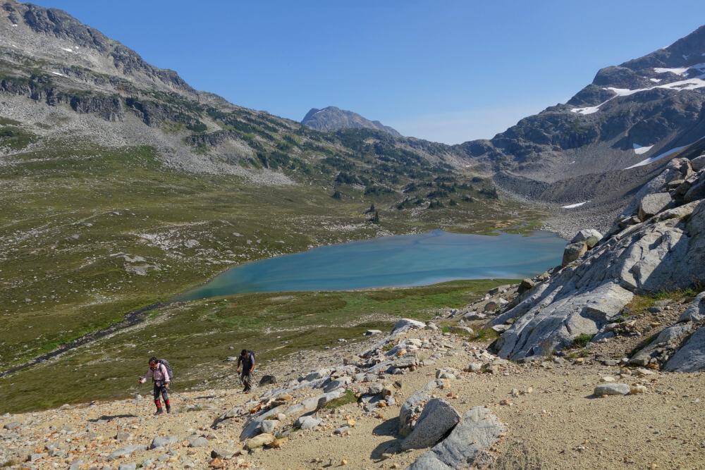
My first "official" BCMC trip, spanning a total of 4 days with couple hours on the final day helping to clear brush on the trail north of Lizzie Lake. Hiked in some 16 km on the first day with Wes, Shuyu and Ian, meeting the rest of the crew who helicoptered to the rustic Lizzie Lake Hut earlier that morning. Hut was full, so we pitched tents on somewhat sloped sites nearby and whiled away the afternoon swatting mosquitos with much jealousy of the others and the cold beers they had flown-in along with the rest of their gear! Finally called it a night, with Shuyu, Wes and I having agreed to a sortie on Caltha the following day. It's the farthest out of the Lizzie area peaks described in the guide and looked to be the most interesting scramble-wise, not to mention offering a great perspective on the incredibly blue Tundra Lake. About 22 km and ~5900ft round-trip from the hut, Caltha promised to be a longish day, so we set the alarms for first light and set out after a hasty oatmeal breakfast.
The path up from the hut is well defined, and ignoring a fork at right that leads to Long Lake, we proceeded up into a large alpine basin containing Arrowhead and Heart Lakes. Up-and-over Tabletop-Arrowhead saddle, taking in our first views of Caltha and the smoky skies we would be hiking in the rest of the day before traversing below Tabletop to gain the long NE Ridge. Down to the Tabletop-Tundra Saddle, then gaining a bit before making a tedious traverse towards Caltha Lake. We stopped for a rest here before resuming the grind now up Caltha's West Ridge. Easy travel here hiking up heathery steps to reach the edge of a large talus bowl, which we traversed across to snow patches at a high saddle on the South Ridge. Contoured around the south face over blocky terrain to reach a higher saddle before completing the final scramble to the top. WHOA! Big fire just opposite us in the very upper reaches of Stein River Valley! We're talking a crown fire with flames towering up over the treetops! A bit unnerving being so close and noting how quickly it was advancing up-valley we chose to cut our time on the summit short. Outstanding views with glaciated Skook Jim Mountain just to the SE and of course Tundra Lake at our feet and seeming like it was Photoshopped-in, plus so much more! Words don't do it justice. Discover it for yourself!
Descended Caltha's N-NW Ridge to make a fun loop, with steep and somewhat exposed terrain for a short bit before the usual blocky terrain lower down. Picked up the trail again at the Caltha-Tundra Saddle then proceeded on the long return journey past all the lakes and saddles we passed by earlier in the day. Beautiful late-afternoon lighting and shifting winds made for mostly smoke-free skies and improving visibility to close-out the day. Back to the hut after 11-12 hours and feeling very satisfied. Unfortunately, our luck ran out the next day when Wes and I attempted to hike up Long Peak in the rain. Hiked up past Long Lake in hopes of a clearing that never came, and after a few hours of plodding around in a foggy downpour, we called it and returned to the hut. Our 4th and final day of course dawned with clear skies again, but we had a couple hours of trail clearing and a long hike out to contend with so Long Peak would have to wait for another time. Ugh! Fantastic area, and 100% will return for the Long-Tynemouth-Arrowhead-Tabletop-Anemone Traverse!
It would be very much appreciated if you please ask before copying and/or re-publishing content from any part of these pages. To do so, please click here to send a message via feedback form.


 as seen from Cleveland Dam.")


