


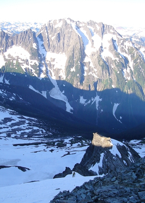
Forbidden Peak - East Ridge, July 2008
 with East Ridge on left skyline, as seen from the summit of Mount Logan.")
I first climbed Forbidden Peak back in July 2002. At the time, completing the classic West Ridge was a milestone for me - it was one of my first technical alpine rock routes and ultimately paved the way for the countless other alpine rock climbs that followed. The route was also the first of the few Steck and Roper "50 Classics" that I have climbed. Boy, I thought I was in the big leagues after that! What's not to like? An airy ridge with excellent granite, awesome position and sublime vistas of glaciers, peaks and lush valleys, and all in the heart the North Cascades. Nowhere else in the range perhaps does one find such a combination at such a moderate grade. Sure, it's easy by technical standards, but that in my opinion does not detract from the aesthetics of the route. The climb is just plain fun, and has a lot of what one wants and little of what one doesn't. If only it was longer. Little wonder then that many return to repeat climbs on the peak.
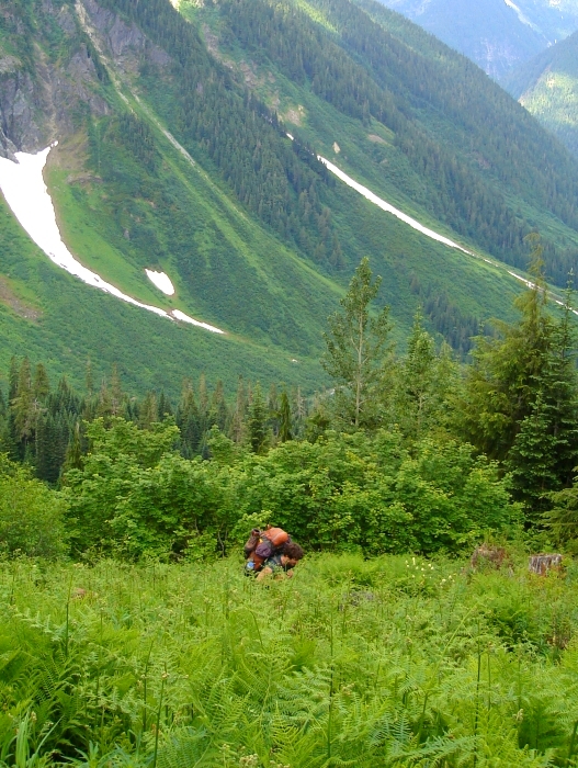
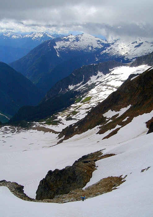
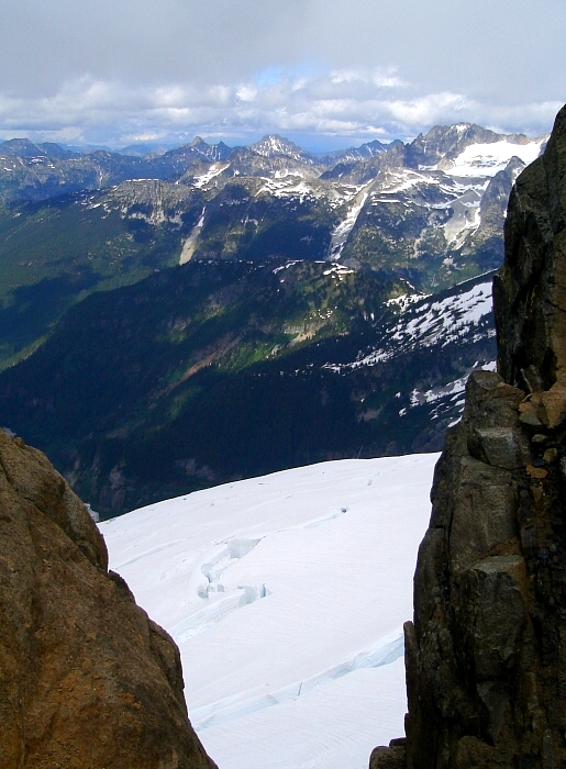
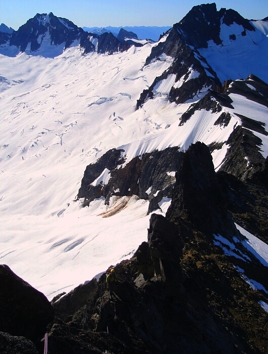
With memories of my 2002 climb now fading into obscurity, a trip to revisit what can arguably be considered the crown jewels of the North Cascades National Park was long overdue. I recruited Eli into joining me, and set my sights on Forbidden's slightly more challenging East Ridge Direct (ERD) this time. Longer and somewhat more committing, with multiple gendarmes that must either be climbed over or bypassed, the ERD presents a uniquely attractive alternative to the often-overcrowded West Ridge. Furthermore, with the mighty Boston Glacier as the backdrop, the position and setting is unsurpassed and easily tops that of any ridge route I have done. With the camping permit formalities behind us, Eli and I proceeded to the all-too-familiar gated road-end at Eldorado Creek and shouldered our packs for the two-mile road hike to the Boston Basin Trailhead. The rangers had informed us previously that the road would be open to Cascade Pass by the following day, but unfortunately this did not fit-in with our climbing itinerary. The hike to camp was uneventful, though the heavy cloud cover felt strangely reminiscent of last year's failed attempt on the ERD. What happened to the "mostly sunny" forecast?
Hoping for a quick afternoon jaunt up Sharkfin Tower's Southeast Ridge, Eli and I took a short nap to allow the weather to clear up somewhat. By 2:30pm we were on the move again, making quick progress up the left-edge of the Quien Sabe Glacier. The clouds finally released their hold on Sharkfin's summit, and occasional pockets of blue were starting to show. We found ourselves at the hidden gully in the cliff band below Sharkfin before long and negotiated a few tricky rock steps before continuing up again on steep snow to the shelf above the cliff band. The wind picked-up considerably here and clouds were streaming by overhead at an alarming clip. I booted up the final slope to the notch at the start of the SE Ridge and waited for Eli to join me.
I quickly donned every last stitch of clothing I had with me, yet still I was freezing my ass off. What's worse, I could barely stay on my feet, as the wind at the notch was so strong. We estimated the wind to be around 40mph, with gusts of 50mph or more. No doubt the climbing on the 5.0 arete above would have been "exciting" thanks to the wind. Neither Eli nor I felt particularly motivated to explore this potential excitement any further. We were really here to climb Forbidden after all. We retreated from the notch and returned to camp. The skies continued to clear after dinner, and by the time we retired for the night the clouds had all but vanished. Hopeful that the wind would also diminish, things looked promising for the following day's climb
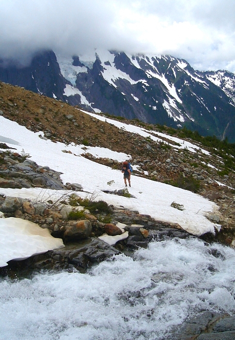
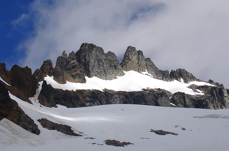
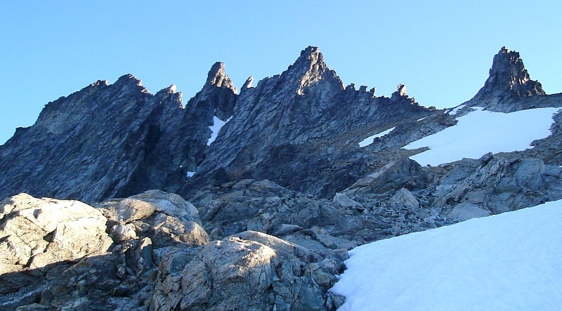
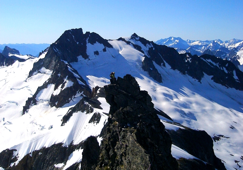
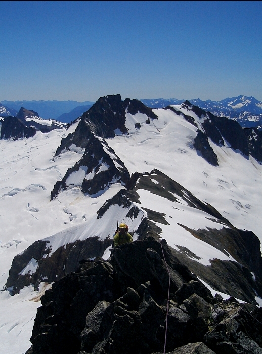
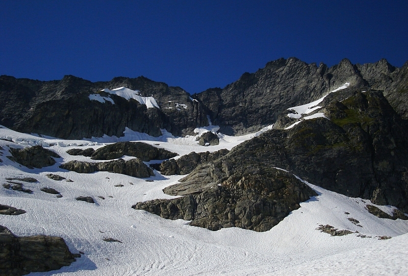
The alarm clock rang at 4:30am, but we didn't stir for another half-hour. By 5:30am we were finally on the move, making quick progress over firm snow towards the basin below Forbidden's South Face. Turning right, we continued up into the basin and followed a hidden gully to reach a high shoulder overlooking Boston Basin with the ever-present Mount Johannesberg looming in the background. We passed the right-most tower in front, and the four smaller towers behind. We climbed up and over the next large gendarme towards the smaller right-leaning gendarme. This we passed again behind, then climbed up and over the next large gendarme. The final two gendarmes (they appear as one from this angle) we passed behind before regaining the crest for the remaining climb to the summit.
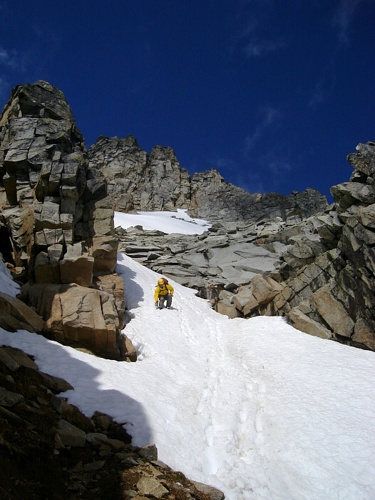
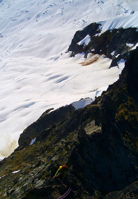
We scampered up some loose rock to a sunny saddle before the first obvious gendarme and roped-up. With the rope doubled-up, and Eli carrying some coils, we proceeded to simul-climb around the first large gendarme and several smaller gendarmes before climbing directly up and over the next large gendarme. I reeled Eli in and had him put me on the belay for the next portion of the climb, which entailed a short down-climb, followed by a mostly level hand/finger traverse along the knife-edged ridge crest. Hand-over-handing it along this knife-edge with several thousand feet of air on either side was one of the highlights of route for me. A short cheval section near the end had me wishing for some extra padding in the crotch! The next right-slanting gendarme looked menacing and I opted not to climb up and over, but rather traverse around it on the sunny north side. Following a narrow and down-sloping ledge, I carefully inched my way to a large notch between this and the next large gendarme. I found this traverse particularly nerve-wracking, as the rock on the north-face of this gendarme leans back making for some awkward moves on vertical or slightly overhung rock. Fortunately, there are good boulders and horns to use as a belay anchor at the notch, for Eli took a short but scary fall near the end of this traverse.
We took a few moments to regroup and proceeded up and over the next gendarme and climbed back down to the notch on the other side. The next two gendarmes are so close together that they appear as one from most vantage points. Rather than climb up and over the first of the two, then have to rappel down into the notch between them, I chose to traverse an easy ledge system again on the north side, hoping to duck back left into the small notch before the final gendarme and climb the 5.8 finger/hand crack that comprises the crux of the route. Stopping at a horn with sling from where I gave Eli a belay, I soon noticed that I had already bypassed the final two gendarmes entirely and was in fact adjacent to the amphitheater bordered by the North Ridge and a spur that descends from the East Ridge. Oops!
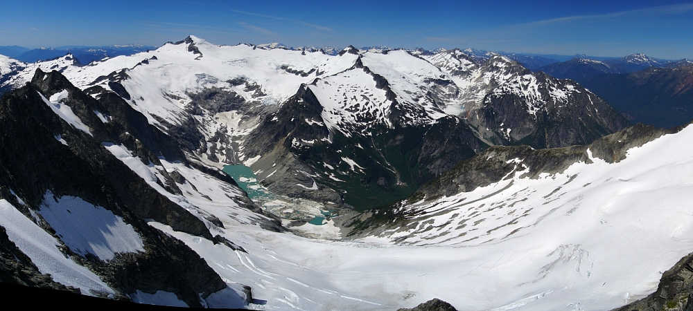
A pitch of steep, but blocky rock saw us back to the ridge crest immediately west of the final gendarme. A bit of scrambling on the crest leads to the summit, which we were able to enjoy entirely on our own. Apart from the one other party we could occasionally see climbing the East Ridge behind us, we had the mountain pretty much to ourselves. The views are simply stunning from up there, of course. All the usual suspects were on display. I even rattled them all off to Eli, proudly noting the ones I have climbed. This surprised even me...damn what is it now, ten years of climbing in the Cascades? The last time I took in this view I could scarcely identify most of the peaks I was looking at, let alone claim to have climbed them. So many adventures are rolled-up in that one view for me. All told, how many miles of trail traveled is that? How many freeze-dried meals? How many gallons of gas to get to the various trailheads in the first place?
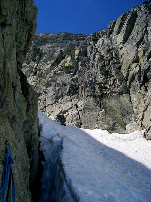
The East Ledges descent didn't look particularly appealing to us, and since we were carrying our boots and axes, it made sense to descend the West Ridge instead. Besides, it was familiar and I figured Eli would appreciate doing an aesthetic east - west traverse over the relatively faster East Ledges descent. Down climbing and two or three raps eventually saw us down to the West Ridge notch. One rap down a shitty gully to snow and another rap down the coulior brought us to a point where we had to down-climb for about 50 ft to reach another rappel anchor in the moat at right. The final rappel deposited us above the 'schrund. Having gone first, I selfishly abandoned Eli to deal with the rope on the final rappel, and high-tailed down the remainder of the coulior to safer terrain in the basin below the 'schrund. Here I waited and waited for Eli, but could neither see nor hear him, despite my repeated calls. Then I heard him yell something, followed by more silence. I feared the worst for a while and even started booting back up to look for him. My imagination got the better of me during those tense moments. What kind of grizzly sight was awaiting me down in the 'schrund? Fortunately, as I neared the 'schrund for a second time Eli eventually emerged from the coulior. He'd gotten the rope stuck on some ice protrusions deep down in the moat and could not free it. I decided not to go back up into the coulior and pursue freeing the rope myself as it was already in questionable shape. Furthermore, the coulior isn't exactly a place I want to spend any more time than I absolutely have to, let alone deal with a rope that's probably irretrievable in the first place.
Back at camp, we lounged in the sun for a while and contemplated staying another night before the rangers finally kicked us out. The hike back out was uneventful, reaching the paved road with two miles left to go shortly before dark. Our timing was perfect too, for we flagged down the one-and-only vehicle returning from Cascade Pass that evening and scored a ride back down to where Eli's car was parked. I'll certainly forget about the lost rope long before I forget this climb. The exposure is unrelenting and although the rock isn't as solid as that found on the West Ridge, it's still quite good. There are also numerous spots along the route where one can bail and rap down to ledges on the North Face in the event that retreat should become necessary. The West Ridge descent is tedious and time consuming, while the East Ledges descent appears loose and unpleasant. It is however significantly faster, as evidenced by the other East Ridge party's down-tracks in soft snow late that afternoon. YMMV. Now go for the Hatrick and climb the North Ridge next!
Click here to view photos.
![]()


